| bienvenue à carquefou | |||
|---|---|---|---|
| Dernière mise à jour à : 12:07 le :07 February 2018, time of next update: 12:08 | |||
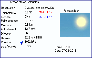
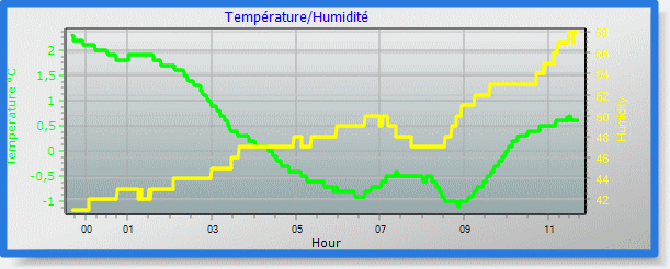
| Météo actuelle | Overcast and gloomy/Dry | Température actuelle | 0.6°C (33.1°F), Apparent temp -1.3°C, Apparent temp solar -1.3°C |
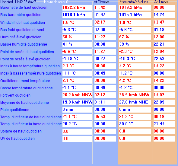
| Temperature Maximum (depuis minuit) | 2.1°C at: 00:00 | Temperature Minimum (depuis minuit) | -1.1°C at: 08:49 |
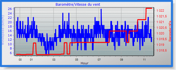
| Vitesse moyenne du vent (dix minutes) | 3.7 kmh (2.0 kts) | Direction du vent (dix minutes) | NNW (348°) |
| Température des rafales | 0.6°C | Rafale maximum (dernière heure) | 22.2 kmh (12.0 kts) at: 11:21 |
| Rafale maximum (depuis minuit) | 26.2 kmh (14.2 kts) at: 07:12 | Maximum des moyennes à 1mn (depuis minuit) | 19.0 kmh (10.3 kts) at: 01:11 |
| Précipitation (dernière heure) | 0.0 mm | Précipitation (depuis minuit) | 0.0 mm (0.00 in.)--- |
| Précipitation Ce mois ci | 8.4 mm (0.33 in.) | Précipitation To date this year | 140.2 mm (5.52 in.) |
| Précipitation maximum par minute (dernière heure) | 0.0 mm/min | Précipitation maximum par heure (dernières 6 heures) | 0.0 mm/Heure |
| Précipitations de hier | 0.0 mm | Point de rosée | -6.5°C (Wet Bulb :-1.7°C ) |
| Humidité | 59 %, Humidex -2.9°C | Barometre corrected to msl | 1022 hPa (QNH 975.0 hPa |
| Evolution de la pression | +1 hPa (dernière heure) | Tendance (dernières 1 heure) | MONTE SLOWLY |
| Evolution de la pression dernières 12 heures) | +4 hPa | Evolution de la pression (dernières 6 heures) | +3 hPa |
| Current solar | 0 W/m² | Current UV | 0.0 |
| Maximum solar (depuis minuit) | 0 W/m² | Maximum UV (depuis minuit) | 0.0 |
| Current 00:00 hours of sunshine today, current sky: Overcast and gloomy | |||
| Sunshine hours for the year: | 00:00 hrs | Sunshine hours for the month: | 00:00 hrs |
| Current evapotranspiration rate 1.0 mm per day. Yesterday's reading 1.1 | |||


Use the RELOAD facility on your browser to retrieve the latest data.